An element of my mapmaking requires that I create the infrastructure that's assigned to each hex. I've shown how this is done previously, here and here, so I'm not going to do it again here. But I am going to talk about a step I've added. [Sorry if this feels like I'm rewriting a post]
The area to be calculated is Nyatria Principality, a medieval province of western modern Slovakia. Here's the map with 20-mile hexes that I made long ago:
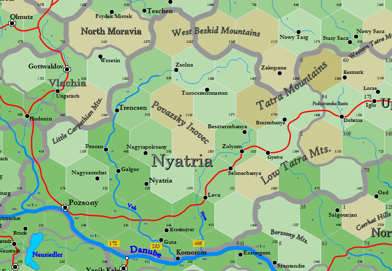
Pozsany is the old name for the modern city of Bratislava, for reference. Nyatria is very heavily populated, 668K people, making it very heavily infrastructured. It shares hexes with Budapest Sanjak (under Ottoman occupation in my game world), which is also heavily populated (531K). The three notes at the bottom, 172, 253 and 465, describes the infrastructure of those hexes as calculated from the south side of the Danube, under Budapest authority.
Briefly, infrastructure is calculated by determining a base infrastructure number for each settlement (Pozsany, Komorom, Nyatria, etc.) and then halving that number as we move outwards for each hex. For example, if the base infrastructure number equals 64, then one hex away it would be 32, two hexes away it would be 16 and so on. Thus the numbers drop very quickly. Think of it as each hex dividing the number to the power of 2.
There are numerous changes in elevation throughout the principality above, with each change of 400 ft. adding +1 to the exponent described. If the adjacent hex is more than 400 ft. above or below the first one, then the number is divided by 4 (2 to the 2nd power, not the 1st). It gets fairly complicated to sort this out, comparing each hex to the one adjacent ... especially if the province happens to be very up and down, like Nyatria. Thus, I spend a little time and add some symbols, thusly:

Yes, it still looks complicated, but I'm quite used to this. If no black line exists, the difference is x2(1), or 2 to the 1st power. A double line indicates x2(2) ... and where a number exists, that indicates the exponent. Thus, as I start calculating the various hexes, I can quickly see how much change each hex crossing produces.
I've added the amount of infrastructure that each settlement hex produces as well. Pozsany has a base of 1348, Komorom & Guta of 230, Nyatria & Galgoc of 333 and so on. Here's what it starts to look like as I distribute the infrastructure across the map:

As can be seen, it gets very cluttered, very quickly, Here I've only calculated out four settlements. What I usually do is that once I collect five totals in a given hex, I condense those totals before moving onto the next distribution.
Those who know me have seen this before, so I won't waste any more time. I've finished Nyatria, which was affecting the edge of a map I'd been creating for tomorrow's post on my new mapmaking wiki, so now I can put down this sort of calculation and go back to designing 6-mile hexes.
Here's Nyatria, finished. There are two hexes that need the adjacent territories done before a final infrastructure can be known.

It all looks so simple, doesn't it?
Beautiful stuff. I always enjoy a refresher of how the sausage is made.
ReplyDeleteSeeing things like this makes me wish I had any idea how to program. Just any clue at all, so that I could provide an application that just takes a map and POW. Roads, Infrastructure, Hex Resources, bing bang boom. You want what's available in town? Click it, pow.
ReplyDeleteThe enormous work you put into your game doing all of this manually is supremely impressive.
This has me thinking again on your tech system, development levels, and trade which got me wondering where you had gotten on a GUT for all that.
ReplyDeletePandred: Shelby over at For H in Hexes is doing a ton of work in re:programming/automating a lot of this and while I appreciate the work being done I also see the benefit of generating step by step, layer by layer manually. It gives me more of a feel for the land.
ReplyDeleteOne of my steps of game prep is to "walk the map." I spend some time either reviewing or building the 20- 6- and 2- mile hexes where the players are and where they're headed. That way I KNOW the map. I know where the bend in the road is. I know where the saw pit is. I know where the cave full of icky stuff is. So when the time comes to ad lib an encounter it fits. I know what the caravan is likely carrying. I know what the tradesman likely does. I know what's grazing next to the field and what's growing IN the field.
I'm no Alexis. Never WILL be. His scale and scope are greater than I want to tackle. But the IDEAS. The approach. The "system." THAT's what I'm trying to learn/adopt.
It's one of my favorite areas in the world. Lovely hiking, good simple mountain food and a Slovak Robin Hood. Lucky players.
ReplyDeleteWhere are you from, Nigel?
ReplyDeleteAlexis, I usually comment as Nigli, but I'm on a shared tablet so I have a different handle. I'm from New Zealand originally but have spent most of my adult life in Europe, mostly in the Czech Republic and more recently in Hamburg, Germany.
ReplyDeleteIn passing, I am interested to note you used Gottwaldov for what's now Zlin. (That's not meant to be a pissy comment, BTW, and it's certainly on the map in my collected 'top secret' Czechoslovakian general staff maps).
Wikipedia says it was called Gottwaldov from 1949 until 1989 ... and so it appears in my 1952 encyclopedia as Gottwaldov. I suppose I never found any information about what name it had in 1650, and assumed the default name; the city is in that part of the Czech Republic that the Germans claimed in 1938, and so again, I assumed it was a German town. I see from Wikipedia today that those assumptions were wrong.
ReplyDeleteI'll be happy to correct the name to Zlin, as wikipedia says. I also have the small region as the "Duchy of Vlachia"; should that be changed?
Duchy of Vlachia sounds like a reasonable name. I know it as Valašsko, which is the current Czech name. The people there speak with a really sing-song dialect.
ReplyDeleteSorry Sterling, your comment went to spam for some reason.
ReplyDeleteI'd like a grand unified theory ... but every time I try to get into it, I find the language gets out of control. Patience, patience.
Hello Alexis,
ReplyDeleteYou mentioned you added a step, but I fail to see it based on what I remember of the process. Could you enlighten me ?
Another thing, if memory serves me right you told previously that the infrastructure is only counted for the local principality/ territory. Has that changed, or maybe Nyatra is considered part of a greater territory thus gaining infrastructure from other parts of it ?
Love seeing those posts, still stir up a desire to get back to the map generator (and yet I don't have the time, barely enough to keep in wirh my players ^^).
Be well.
Vlad,
ReplyDeleteThe "step" that I added is the graphical representation of lines and numbers between hexes before distributing infrastructure. It doesn't change the system, it only adds a creative measure for the landscape to simplify the process.
Infrastructure is only counted for the local territory. That has not changed.
Ah, thank you.
ReplyDeleteI was wondering why you'd need the infrastructure of the Budapest Sanjak, then I realised they were shared with Nyatra, so that must have been the reason. I asked too fast, sorry.
It's completely valid for you to seek clarity, Vlad. NEVER be concerned about asking a question.
ReplyDelete