Showing posts with label Infrastructure. Show all posts

Sunday, May 19, 2024

Dams

When last I did any work on the hammers page of my wiki (which I abandoned to work on the Streetvendor's Guide), my next intended page would have been for "dam."  It's comforting to know that, after leaving off something for about 16 months, the work is still sitting right there, waiting to be done.  I don't have to think of what I ought to do, or want to do ... just what's next.

For a change, and because I need a post, let me produce the page here instead of on the wiki - so that it can be transcribed later.  We want to consider only dams that would be realistically created between the 15th and 17th centuries.  Dams were also made for canals, and canal work was prevalent at certain times in Chinese history, but not so much with the decline and collapse of the Ming dynasty, and certainly the practice wasn't widespread in Europe or anywhere else in the time period specified.  My game, I'll remind the reader, takes place in 1650; for this, I'm just going to pretend I have a game, just in case one pops up.

Dams are primarily constructed to provide a reliable source of water for irrigation, ensuring that crops can be watered during dry periods. Dams also supply a steady flow of water to power watermills. They ensure a consistent water supply for livestock and limited domestic uses, supplementing wells and natural water sources. Community cooperation is needed in maintaining these structures, with locals working together to manage water flow, remove sentiment and repair damage. Understanding of water contamination is minimal, given the time period, so the primary concern is maintaining the water level and the dam's integrity.

Construction involves simple techniques, using local materials such as earth, clay, stone and timber. Rare dams might be constructed with mortared stone. Typically, they're about 3 to 10 yards in height, with a generally modest length, most likely less than a hundred yards.  The reservoir would be quite small as well, most likely not larger than 20 or 30 acres.  A few acres is far more likely.  One benefit is that as water settles in a reservoir, sediment and particulates drift to the bottom, producing a clearer, cleaner water at the surface.  This isn't pure of course, as various contaminants and microorganisms would persist ... but to the late Renaissance mind, the water would taste better.  Modern concerns just aren't present, as the source of disease and other maladies is largely misunderstood.

In my infrastructure system, dams occur with type-5 hexes that have at least 2 hammers (H).  For these conditions to be met, the hex must have a significant river, not a little stream ... so there's plenty of water available with which to make a reservoir.  Such a dam facilitates the growth of population in the hex and supports the water needed to irrigate more land, so that type-5 hexes also have a notation of 3 food (3F) as well (type-6 only have 2F).  Type-5 hexes without a sufficient stream also produce 3F, without the 2 hammers, so we may assume that more irrigation is not the only reason for this.

It needs to be stated, though, that the extra food on the map stipulates not production, but surplus.  Meaning that a type-5 hex with 3F and 2H would probably support food than the same type hex with 3F and 1H.  Not that this is very important, and these numbers probably are confusing, but this can be pieced together by following links on the hammer's page, linked above.

Dam failures did occur, due to inadequate design, substandard materials, poor maintenance ... all the reasons they still fail now.  Of course, a thirty acre reservoir, when it breaks, isn't going to cause all that much damage.  Flooding might threaten a few, but the larger consequence would be crops lost, lands flooded, and the difficult task of rebuilding the dam.  There might be considerable fallout as persons left the area or as a few engineers were given the axe ... not in a nice way.

The Dutch began building dams to create "polders," low-lying tracts of land that could be farmed, in the 12th century, building on work done by earlier cultures, including the Egyptians and Romans, and in fact the Danes during the time of the Vikings, starting four centuries earlier.  Polders are a major infrastructure practice; as such, I'm adding it to type-3 hexes, needing 3 hammers.  Holland and Zeeland are extremely dense in population/infrastructure, so there would be a lot of such hexes.

 At the time of my game, before 1650, nothing like the impressive size we know today were attempted; large polders could encompass several hundred acres, but this is still less than a square mile (which have 640 acres each).  Small polders covered just a few acres, much like the size of reservoirs we discussed above.  So, keeping these things small in one's mind is a good practice.

Many reservoirs contain fish, having been drained from rivers, so there's little need to stock them, but fish were captured from nearby streams and then transported to reservoirs to be released.  This carrying was done in baskets, barrels and buckets, as available.  Often, there were designated places along the shoreline of larger reservoirs (and natural ponds as well) for the intended purpose of stocking, where the water was deep and the fish had ample space to disperse and acclimate.  Stocked fish are typically carp, trout, perch and whatever else might be native to the region.

I just had a vision of players rescuing some travellers with two wagons full of what looks like beer, but are in fact barrels full of water and baby perch.

Well, that's all I can think of.


Monday, December 12, 2022

World Description, part 1 of a billion

This is the beginning of a very long headache:


But it's also a template, one that can take us a long way.  We start with the policy of making individual parts, one at a time, so the pieces can be fit together into a structure.  Here I started with isolated farms and built towards a thorp, until I had enough to create the page above.  There are pieces that were bypassed along the way, but these can be managed too.  This is the power that a wiki provides: it keeps track of everything that hasn't been done yet, so I know my next steps as a designer.

I won't lie and say I wasn't challenged by the writing of the above page.  It's highly detailed and undeniably dry in parts ... but as a DM, the opportunities are there to take a simple bit of information and apply it meaningfully.  Meanwhile, it provides a transition between the "village" and the "dungeon" that's all at once familiar and yet mostly overlooked.  Of course the players should pass through an area of backwardness before getting truly into the wilderness ... but since there's a lack of how such places are formed, or what they find important, it's difficult for a DM to present it in game terms.

My goal is to provide a concrete example of worldbuilding posts I set out to write a year ago.  Here is where the people live, here's what their homes look like, here's what they do, here's how many of them there are, here's the size of the civilisation footprint.

The trick is to take this template and move forward with it.  Hexes only become increasingly more intricate and diverse from here.  Type-7 hexes are, by comparison, staggeringly simple.  But I'd like, imaginatively, to ultimately be able to define a whole city in these terms, not as a whole unit (which would be impossible), but by constructing the social strata out of which the city — and the realm — is built.  Not an easy task.  And I'm sure I'll take long breaks from it, as my motivation dries up.  I think, however, my readers have learned that tasks I leave eventually get taken up again.  And each time I come back around, I always have new ideas, new ways of looking at it, and new energy with which to work.

It just takes time to recharge my batteries on any given thing.

I'm quite sure that, for as long as this go-round lasts, my readers will be thankful for every bit and piece of this puzzle as it's created.

Friday, November 25, 2022

Whole Facilities List

I've finally complete this page:


Personally, I consider it a work of absolute genius ... remembering that every facet of the page depends upon a random generation determined by my infrastructure distribution rules, which in turn are entirely developed out of information on encyclopedia-determined towns and cities, systematically calculated population figures and a distribution of "settlements" that I apply according to GoogleEarth, not my own reckoning.

Thus, the whole system builds and functions spatially in the setting without my personal intervention.  I build as the numbers tell me.

Fantastic.

Wednesday, November 16, 2022

Nyatria

Okay, if you're not into maps and demographics, get ready to be bored.

An element of my mapmaking requires that I create the infrastructure that's assigned to each hex.  I've shown how this is done previously, here and here, so I'm not going to do it again here.  But I am going to talk about a step I've added.  [Sorry if this feels like I'm rewriting a post]

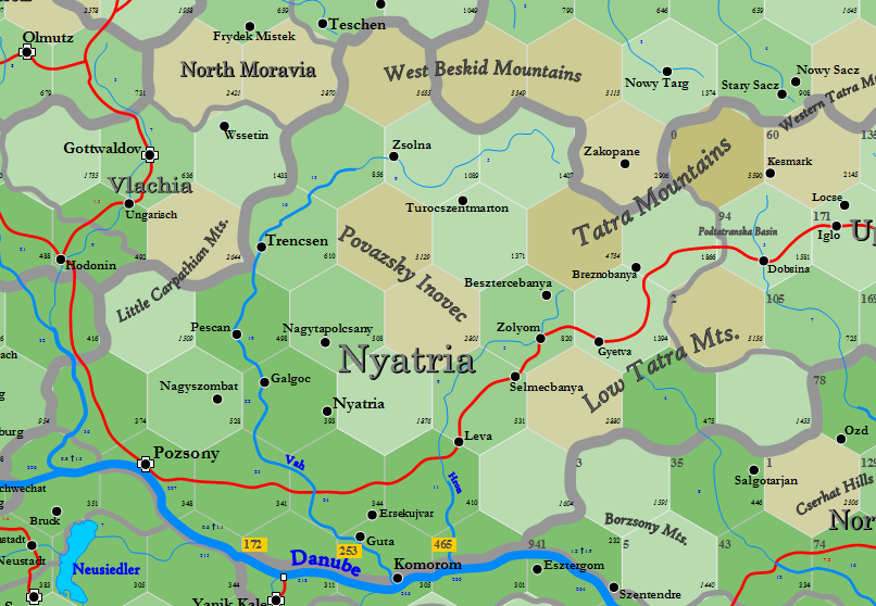
The area to be calculated is Nyatria Principality, a medieval province of western modern Slovakia.  Here's the map with 20-mile hexes that I made long ago:


Pozsany is the old name for the modern city of Bratislava, for reference.  Nyatria is very heavily populated, 668K people, making it very heavily infrastructured.  It shares hexes with Budapest Sanjak (under Ottoman occupation in my game world), which is also heavily populated (531K).  The three notes at the bottom, 172, 253 and 465, describes the infrastructure of those hexes as calculated from the south side of the Danube, under Budapest authority.

Briefly, infrastructure is calculated by determining a base infrastructure number for each settlement (Pozsany, Komorom, Nyatria, etc.) and then halving that number as we move outwards for each hex.  For example, if the base infrastructure number equals 64, then one hex away it would be 32, two hexes away it would be 16 and so on.  Thus the numbers drop very quickly.  Think of it as each hex dividing the number to the power of 2.

There are numerous changes in elevation throughout the principality above, with each change of 400 ft. adding +1 to the exponent described.  If the adjacent hex is more than 400 ft. above or below the first one, then the number is divided by 4 (2 to the 2nd power, not the 1st).  It gets fairly complicated to sort this out, comparing each hex to the one adjacent ... especially if the province happens to be very up and down, like Nyatria.  Thus, I spend a little time and add some symbols, thusly:


Yes, it still looks complicated, but I'm quite used to this.  If no black line exists, the difference is x2(1), or 2 to the 1st power.  A double line indicates x2(2) ... and where a number exists, that indicates the exponent.  Thus, as I start calculating the various hexes, I can quickly see how much change each hex crossing produces.

I've added the amount of infrastructure that each settlement hex produces as well.  Pozsany has a base of 1348, Komorom & Guta of 230, Nyatria & Galgoc of 333 and so on.  Here's what it starts to look like as I distribute the infrastructure across the map:


As can be seen, it gets very cluttered, very quickly,  Here I've only calculated out four settlements.  What I usually do is that once I collect five totals in a given hex, I condense those totals before moving onto the next distribution.

Those who know me have seen this before, so I won't waste any more time.  I've finished Nyatria, which was affecting the edge of a map I'd been creating for tomorrow's post on my new mapmaking wiki, so now I can put down this sort of calculation and go back to designing 6-mile hexes.

Here's Nyatria, finished.  There are two hexes that need the adjacent territories done before a final infrastructure can be known.


It all looks so simple, doesn't it?

Wednesday, February 9, 2022

Worldbuilding 5a: Location, Location, Location

I have a post for 4f: Muetar, but for the time being let's skip ahead.  So far in the series, the emphasis has been on comprehending the world's macro-structure ... how geography and political/economic relationships are understood and expanded.  Let's zoom in a bit.

Recently, between writing about worldbuilding I've been involved in my own.  I hope to run D&D sometime in the next couple of months, after a very long hiatus.  We've all had our shots and we're hoping that Omicron is a "turning the corner" moment and not a prelude to something horrible.   Deaths all over Canada are dropping (157 nationwide yesterday) as are cases (7,184) ... so here's hoping that in two months we'll be back to where we were in June last year.

With the expectation of playing, I was able to procure a used table dirt-cheap.  This beauty is 90 inches by 42, is solid as a rock and has something of a medieval like motif on the surface.  I'll be trying to find space to varnish it this summer.  Unfortunately, I haven't any chairs.  We were able to buy a set on order at a fair price (ouch though, a bit), and we've been told it will be a month or two, with the transport back-up and all.  Which is fine.

Until recently, I've concentrated on mapping Norway, as the online party was there.  As things look now, I don't know if I'll ever be able to pick that campaign up again, as it's an enormous time expenditure and I'm working like a very happy dog these days writing.  That, incidentally, is why I've taken to blowing off a little steam about politics lately.  Don't worry, this is always going to be a D&D blog.

So, I've turned my attention to the party's home territory, which I last mapped about eight years ago.  My map-generation system has advanced since then, and so I'm starting an overhaul of the players' domains.  A little retconning, if you will.  This means the appearance of little villages and greater detail than the party's seen previously, plus a heightened inclusion of basic infrastructure.  I'm rather pleased by the results of this, actually, more than I expected to be.

[Yes, that is a framed Airboy poster in the background.  My first wife bought that, actually, in 1986.  Which makes the poster something like 35 years old.  A 12 by 17 inch version costs $35; I found someone selling the original for $225.  I doubt I'll ever sell it].

Without further ado, here's a rough generation of the area surrounding Kronstadt in Transylvania and the player's home territory ... namely, the town of Garalzapan and the surrounding hex.  Each hex of this map is 6.67 mi. in diameter, or about 10.73 km.


The map isn't intended to accurately reflect this part of modern Romania, though it lifts names casually even as this means shifting the actual town several miles from it's Earthly location.  For example, there really are towns named Miclosoara, Venetia and Tarlungen, and these are sort of where they ought to be, but not actually.  After many years of doing this, I'd rather build my own inaccurate but fantastical maps than use modern maps with modern features and modern populations.  I don't care about accuracy.  I care about providing a nifty setting for the players.

There's much going on here, lots of opportunities for adventure, but I'll start with the players' land and talk a little of the party's history.

The party acquired their parcel of land in Transylvania as a granted wish, following a very long campaign in which they returned a befuddled, lost-her-memory Greek Amazon demi-god to her people.  

They were asked where in the world they might want to settle down and "Transylvania" was agreed upon after a long discussion.  This gave them ownership of a piece of land about 2 miles square, but it didn't give them a "title."  That came later.  The party comfortably settled in, having made some enemies in their wanderings around the Caspian Sea, including the very powerful wizard who'd previously held the befuddled Amazon as a slave — and also an unknown enemy acquired by two players individually pulling the same identical card from a Deck of Many Things.  Yep, "enmity between you and a devil."

Now, people can badmouth the Deck all they like.  I haven't used it since that last incident, which was about 2008, but in my experience every time I've used it, players just can't resist.  Looking at the cards, the odds are very against the player — but that doesn't matter, because in gambling, the odds are always against the player.  That's how gambling works.  I've had many a player who refuses to draw; I would probably refuse to draw myself.  However, I've never had a whole party refuse to draw.  Invariably, one or two people decide to draw while the others state their resistance.  Then, as the draws are made, a doubter will suddenly change his or her mind.  Usually, good or bad results notwithstanding, three quarters of the party will usually draw.  The event, done once in a whole long-running campaign, is memorable and rather fun.  I'm always happy to pay out as a DM — though I've never had anyone draw the 50,000 bonus experience card.  I don't see how that would unbalance a game, so I'm fine with it.

So, the party.  They start roaming around, checking out their land ... and find a shrine in the forest about two miles south of their hastily structured settlement — really, not much more than an encampment.  I'm looking around at Romanian mythology and I find reference to "Xalmoxis" — variously with a "Z" or an "S" — that equates the Thracian god with the Celtic Dis Pater ... and whether there is a connection or not, I make the rather obvious leap that the coincidence is brilliantly on the nose.  Thus, the players discover the name of the shrine's patron, find a secret entrance under the shrine, walk right in, poke about, find a portal, and willingly choose to walk through it, having no idea where it goes.  Every player not having the enmity of a devil are refused by the gate; the other two are whisked away to the first level of hell.  There, though mortal, they're imprisoned and tortured.  Don't tell me I don't know how to make D&D fun.

So, the 6th level party rushes about getting knowledge of where they are, obtains some help from two well-connected Transylvanians, a cleric and mage, get boosted to the outskirts of the City of Brass and manage to rescue their friends ... while unfortunately fumbling a +2 spear into the River Lethe, the River of Forgetfulness.  The Druid has not forgotten.

Escaping hell (they were in the suburbs, after all), they make it out onto the surface ... in the frozen waste of the upper Pechora River, as it happened.  I rolled randomly.  It took some effort to get home, during which time the players acquired about a level and a half, growing to 7th-8th level and acquiring a pet mastodon, of all things.  When they got back to their land, after 18 months being away, they found the valley laid waste and their followers huddled in Kronstadt.  A large contingent of goblins, supported by a squad of drow elves, had fortified themselves in the mountains.  The party raised an army, with help from their earlier contacts in the Transylvanian court, and that led to the battle that's been posted in full on this blog.

That battle took something like 9-10 sessions to play out.  Something like 700 combatants took place and we played the whole combat out exactly as we would any other combat, without shortcuts or single rolls for whole units of men.  And yes, this means my personal combat system of stunlocks and full tactical movement.  The party LOVED it.  I gave them several opportunities to simplify the combat if they wished, since I didn't right forcing them to play it all out, and they unanimously refused to reduce the complexity.  The battle ebbed and flowed with spectacular magnificence, complete with moments of unbelievable luck (both good and bad), ingenuity, bravery, sacrifice and yes, player death in some cases.  Two of the dead were not raised, one because they chose to start a new character and the other because the resurrection survival roll failed.

As the party did the deed with the help of a small contingent from the court and a larger contingent from a neighbouring Lord, observations of the party were made and it was decided they were a good group to provide some strength to Transylvanian's eastern border.  The party decided the mage Garalzapan (now 9th level after the treasure boost from the war) was their "leader," so he became "Baron Garalzapan."

The little symbols on the party's hex deserve a little explanation, so here goes.  I've discussed this before, at enormous length, so I'll skip over much of the explanation and only provide an update for where my thinking has brought me so far.

The white "3" means this is a type-3 hex.  The three bread slices indicate that the food raised within the hex will sustain 490 persons yearly.

The two coins represent a production of 210 g.p., from goods and services, meaning that general wealth accumulates by that amount yearly; with a 1% per month wastage, resulting from damaged property, hoarded material and coins that are simply lost, accumulation ceases to increase after 7.92 years ... so that in "liquid" terms, the hex has about 1,663.2 g.p. in circulation (this counts c.p. and s.p. also).  With a typical medieval velocity of 3, the transactional value of this money is 4,989.6 g.p.  An estimated 2% of this capital flows through the player's hands each month, in taxes or in services, or 99.792 g.p. per month.

Folks can quibble about the logic of this, but it's a fantasy game and I don't care.  It's a satisfactory number and it works as a system.  So pfffffffft!

Now, "hammers" have always been a problem, but at last I have a solution for these.  They represent a series of thresholds for the presence of various physical forms of infrastructure.  Without digging into it too obsessively just now, 3 hammer symbols indicate 7 "hammers," which indicates that within the hex there's a windmill (if there were a river it would be a watermill), a well large enough for a village, sign posts, a public storehouse, a bakery, a way station (like a protected walled campground), a sawpit where wood can be purchased, a local shrine (not the one to Xalmoxis), a stone quarry, some mining, a stone gatehouse, a barracks with posted soldiers, a chapel, a gallows and a carter post (from which goods are regularly transported to Kronstadt for a fee).  Some of these things were built by the players but if not them, then private citizens have added these features.

I'm tweaking a system that allows bigger settlements, like Kronstadt or Sankt Georgen (note the specialised black town symbol as opposed to the brown one for country towns and villages) to count the hammers of surrounding hexes, enabling big centers to accumulate infrastructure like regular festivals and fairs, castles, theatres, bath houses, courthouses, arsenals, bardic colleges, hospitals, auction houses, observatories, banks, cathedrals and more.  Such a system would allow me to glance at the number of hammers on the map and know immediately whether a particular settlement had an inn, a monastery, a garrison, a money lender and so on ... dictated by the place's location in relation to other large built-up hexes, not just its own.  Thus, where the population is really dense, even an opera house is a possibility.  My game does take place in the 17th century.

Okay, we're going to talk more on this map, but this is enough of an introduction for now.  I'll expand the map a little more and we'll get down to players moving through the setting it represents.


Saturday, January 6, 2018

Expanding Wowotu

To begin, here is an update of Wowotu's full infrastructure, shown on the right.  I have adjusted the color scheme, so that hexes without any infrastructure, regardless of terrain, are now grey in color.  Settlement hexes are rich green, non-settlement plains are a pale greenish-yellow and hills are a slightly greenish-brown.

Because of terrain and distance, Wowotu is broken into five districts, departments, provinces or counties, whatever nomenclature we might choose.  I'd like to add the infrastructure numbers for each district:  Port Tethys-Avalon, 147; Nagoya-Fenris, 57; Cork, 40; Hoth, 12; and Sarai, 8.  This is a total of 264.

This would be a higher number if the settlements were not constrained by terrain, and could spread their influence more easily.  However, whatever the infrastructure, the population total would be static; basically, infrastructure measures communication, not population.

Still, we can now divide the population by the infrastructure: 39,166 by 264 equals 148 people per point of infrastructure.  This is something we want to keep in mind as we build the hexes.

Next, let me admit that I don't intend to expand the whole map into 6.67-mile hexes.  I could do it, obviously, but it would take time away from my actual world and it isn't necessary to make the point I want to make.  So I'm going to show the Port Tethys-Avalon district, partly because it's the largest and partly because it is the most isolated.

This does create a dilemma, regarding the references that I had the readers choose.  Normally, I would make the whole region, then randomly distribute the references among the possible appropriate hexes where said reference could occur.  For example, mining camps, where we would find iron and gold, occur in type-6 and type-7 rural hexes.  So after expanding the whole map, I would add up all the possible type 6 & 7 hexes, roll randomly and place the gold or iron reference.

Here, I'm going to place all twelve references in the Port Tethys-Avalon district.  This is not too many for an area of this size; most of my game's regions of this size have at between 20 to 40 references.

Okay.


Yes, I know, not very exciting.  But nonetheless, the system gives some structure to the hex surrounding Port Tethys.  Remember, there are nearly 12,000 people in this hex alone.  The settlement itself accounts for most of that; type-"2" indicates that Port Tethys is a commercial city, so right off we can put the two market references chosen by the readers in place.  Avalon won't come close to this.  Port Tethys would have a repair shipyard, even if there were no shipping reference; but the readers did designate a ship yard so the city does build ships.

The other type-2 that we generated is a rural hex; and as it happens, consists of a manor house with a small village surrounding it; and knowing it exists, we can give that village a name (I'll just go ahead and call it Rainus.  There's a 1 in 4 chance of it possessing a shrine ... which it does!  We're on our way.

Past that, we should hold off on guessing where the other references will go.  We only need to know for the moment that the type-5 rural hexes are occupied by grouped freeholder farms (no lords on that land), while the type-7 hex is a marginal area with isolated homesteaders.

I'm going to leave off now, and get into all the delicious grittiness after.  It has taken a long time for me to write this post. I'm going to finish by giving the numbers (but not the terrain, I'll add that again with the next post) for the rest of the Port Tethys-Avalon District).  Just for consideration.


The grey would be an arid, near-desert wilderness.

Tuesday, January 2, 2018

A Bigger Hex into Smaller Hexes

The 2nd-stage process of expressing infrastructure is one that modifies this single hex:

Figure A

Into these 7 hexes:

Figure B

And specifies what those hexes are.  Somehow, that number "10" needs to be distributed into the seven hexes, so as to breath life into our empty hex.

I have discussed this process, but I'm not content yet that I've gotten the message fully across.  Therefore, I'd like to pause before continuing with Wowotu and discuss a part of this process in detail.

Let's assume for a moment that we're looking at the hex before Avalon was founded, before any people settled there.  At that time, the hex would be completely wilderness.  Rather than an infrastructure of "10," the hex would have an infrastructure of "0."

If that were the case, then each of the seven hexes inside the hex above would be a "type-8" hex.  Type-8 means wilderness; no meaningful player-race civilization exists.  This would be a place for monsters.  Feasibly, there might be a kobald village, but we don't account for that except in game play; as far as our map is concerned, a type-8 hex is adventure country.

For civilization to exist, we need an infrastructure of no less than "1."  As can be surmised from the earlier Wowotu post, this would likely be a hex somewhat distant from a city or a town, or perhaps in a hex adjacent to a village.  That "1" infrastructure transforms only one of the seven-hexes in Figure B from a wilderness hex to a civilized hex.  The other six hexes of what was Figure A would still be wilderness.

That new civilized hex, created from our "1" infrastructure, would be a "type-7" hex.  Let's assume for the moment that instead of having a "10" infrastructure as shown, Avalon has but 1.  As the settlement is the most important hex among the seven, our type-7 hex would be 0203, where Avalon is placed.

This single hex in the wilderness, with Avalon, would be what I am calling a "type-7 settlement" hex.  I wrote a post last month about type-6 and type-5 settlement hexes.  Type-7 is even smaller.  Here is my description for a type-7 settlement hex, for a Dev-7 region:


A lot of meat there, but we are still talking about a 6.67-mile diameter hex with about 150-200 people in it, about 5-6 per square mile.  Mostly empty.  And surrounded by six similar hexes that would be even more empty.  Basically, the frontier.

Now, if the Avalon hex in Figure A had a "2" infrastructure, what would that mean?

The most obvious answer would be that there were two hexes that were occupied, both type-7.  One of these would be the Avalon hex, and one of them wouldn't.  The other hex wouldn't necessarily be adjacent to Avalon; it would be located wherever the land was best.  One thing about the other hex, though, it wouldn't be a settlement hex.  It would be a "type-7 rural hex."  What would that look like?


Now, this would also a description of the Avalon settlement-hex, outside the actual village, if the Avalon village were a type-7 hex (it isn't, we're just pretending here).  The table above describing Avalon needs the countryside description as well, as the type-7 settlement obviously does not occupy the entire hex.

I'll stop the reader here, however, and point out that a "2" infrastructure wouldn't necessarily mean two type-7 hexes.  It could mean a single type-6 hex instead.  How does that work?

Let's have a look at this table, which at first glance will seem a trifle confusing:

Figure C

The column on the left indicates the infrastructure number.  I have only included the table up to an infrastructure of 6.  The whole table goes up to a total of 448.  At 448 infrastructure and above, every 20-mile hex (figure A) is made up of seven type-1 hexes.

The Base cost shown under each type on the table above indicates how many infrastructure are needed to make that hex.  If you look at the two rows that list an infrastructure of "2", you will see that one alternative would be 5 wilderness hexes (type-8, no cost) and 2 type-7 hexes (cost 1 each).  A different alternative would be 6 wilderness hexes (still no cost) and a single type-6 hex (cost 2).

A type-5 hex costs 4 infrastructure; a type-4 hex costs 8 infrastructure.  And so on.

Okay, apart from some questions, we can move onto to figuring out the rest of Wowotu's infrastructure and start carving up the larger hexes into little ones.

P.S.,

The table for type-7 rural hexes notes that a mining camp might exist in the hex.  This is where we would potentially place our references for gold or iron (salt and limestone are quarries, not mines).  However, type-7 rural hexes are common.  We would want to randomly distribute the two references among all the type-7 hexes in Wowotu, once we knew where they appeared.

Sunday, December 31, 2017

Wowotu

So, we have a big, empty map.

From the various references, I'd describe the region as fairly dry, with semi-arid deserts encroaching on the region from the east and south.

The references the readers picked, presuming I haven't missed something, include limestone, salt, iron, gold, tools, hosiery, shipbuilding, rice, two sheep and two markets.  That's four mineral resources, three crafts and three agriculture.  With two markets, one might think this a transshipment region from the interior; however, the two towns and the city are all nesting in highlands (Hoth and Sarai are only villages), with no easy access to the hinterland.  Therefore, most likely, there is no hinterland.  It is all desert.

I'm not going to place the references yet, but I have an eye to putting the rice near Port Tethys or Fenris, since rice needs a lot of water and the water-laden winds are likely from the western sea.  The other resources could go anywhere.

[as an aside, let me say that I enjoyed messing around with the bevel option on the new publisher; unfortunately, it isn't practical for a lot of map-making, as two beveled images can't be made to bevel as one object ~ so my complex, multiple-image maps that I usually draw can't be so upgraded.  Still, I've used it here because it is a one-off]

The next step, now, is to create a layer of infrastructure over the whole map.  This requires a few calculations ... but as I know my readers hate math, and don't like to use it more than necessary, I shall try to propose methods than any 4th grader could employ.

If we say the borders exactly cover the map (they probably shouldn't, but let's not quibble), I count 64 hexes that have land.  I count 34 coast hexes and 30 pure land hexes.  For the sake of establishing an area measurement, let's count every coast hex as 0.7 hexes (I tried to draw them more land than water), so that we can say the total area of Wowotu is 53.8 hexes.  With a 20-mile diameter per hex, This makes the region a little larger than Belgium, a little smaller than Switzerland, about the size of Taiwan.  It is not quite the size of Connecticut, Rhode Island and Massachusetts combined.

Next, I said I wanted the region to have a Development Level of 7.  This is a matter of population density, so we want to slather an appropriate number of residents over the region's surface.  This is an average of 728 people per hex.  That gives us a total population of 39,166.  This is a somewhat sparse region.  But of course, the population is not distributed evenly.

The readers chose Port Tethys as the main city, and Nagoya and Cork as towns.  This makes Avalon, Fenris, Hoth and Sarai villages.  Without getting detailed in the exact count of population for each (which I usually do), truth is we can get around that.

Think of the city as four times larger than the town, and the towns as four times larger than the villages.  If it helps, a village has 500 people, a town has 2,000 and a city has 8,000.  But like I say, we can skip the exact numbers.  What matters to us is the infrastructure numbers we need, to determine the hex details.

Based on the population, our base infrastructure numbers, awarded to the settlements, is 147.  This is reckoned from 1 infrastructure based on 267 people.  As will be noticed, however, the infrastructure number is very soft; the total expands as it reaches out from a settlement.  Never mind that right now.  Just concentrate on that base number of 147.

If we count each village as 1 point, each town as 4 points, and the city as 16 points, we can distribute that 147 points among a total of 28 settlement units.  We could, if we wanted, just assign points to settlement units, however we wish, but let's do it by the numbers.  By this reasoning, each settlement unit is entitled to 5.25 points.  Port Tethys gets 84 infrastructure, Nagoya and Cork each get 21, and the four villages each get 5.25.

Let's just go ahead and pick up all those fractions and give them to Fenris, giving that town 6 infrastructure and the others 5.  We can mess around if we want, giving three of Port Tethy's total to Avalon, or four more to Cork, or we can shift some of Cork's to Nagoya and so on.  The only thing is, if Cork is a town, we would expect it to have a much higher infrastructure than, say, Hoth.  If we do any shifting around, then, we ought to keep those shifts small.

I'm going to limit the shifts to the one extra point I give to Fenris from the other three villages.  I will make all the other calculations with the static numbers.  The reader should see that these base numbers will not mean that Cork and Nagoya wind up looking the same, with each having 21, or that the villages will appear likewise similar.  The topography will take care of that.

I've presented my method for calculating infrastructure already, both here and here, so I don't want to get bogged down in this again.  Some things that are different in this case, however, deserve mentioning:

  • Infrastructure calculation does not cross pure sea hexes.  It follows the coast, but there simply isn't enough ease of travel across sea hexes to enable the spread of roads, communication and development.  Therefore, the channel between Nagoya and Port Tethys doesn't allow a spread o infrastructure between them.  I know, some will disagree, but remember that a 30 mile separation is quite a good way, that isolation creates scarcity (which is good!) and that infrastructure is not trade - it is infrastructure.
  • Ordinarily, an infrastructure number is halved from hex to hex, when the hexes are of nearly the same elevation.  We don't have any elevation numbers for these hexes, so we're simply going to calculate infrastructure as dividing by four either in or out of a highland hex.  

I will demonstrate with the map on the right, calculating the infrastructure emanating outwards from Port Tethys.  Because the city is on a plain buttressed by a wall of hills, the infrastructure drops pretty quickly (ignoring fractions).  81 turns to 20, which turns to 5 within in just two hexes.  Take note that Port Tethys does not infiltrate Avalon with a quarter of two hexes having 20 points each; it is the distance from Port Tethys that matters, not the number of hexes that the distance can be passed through.  Note also that before the influence of Port Tethys can be passed to the flatland hex beyond the hills NE of Avalon, the infrastructure has dried up.

I'll skip making a similar map for Avalon's infrastructure spread.  It is pretty simple.  Avalon starts with 5 points; it spreads 1 point outwards to each of the five highland hexes surrounding the village.  After that, Avalon's influence has also expired.

The final infrastructure for this part of Wowotu, then, looks like this:


That was easy.  Now just think what a difference it would have made if hex 0301 or 0302 had been left without highlands.  The corridor between Port Tethys and Avalon would have increased amount of Infrastructure from the city four-fold.  Without the highland in 0510, Avalon's influence would extend twice as far along the coast.

The reason for this process is also simple: it is intended to demonstrate what the distribution of development ought to be, based on population and topography.  If you're creating a lot of map, you're not just throwing darts at the wall.  The method gives a logical and familiar distribution for way that communities form and drift over the landscape, in a way that players will find predictable.

And IF the players decide to settle, they can look at a map like this and see their options.  The semi-sparse infrastructure region north or south of Avalon? Should they build in the hex just outside the infrastructure?  Or closer to Port Tethys?

We haven't done any more than squiggly lines on a page, and already we have clear avenues on where to build our adventures, not just in terms of where the dungeon is, but what the dungeon is next to.

With the next post on this subject, I'll show the rest of the infrastructure numbers, and we'll start to lay out the Port Tethys-Avalon country, seeing what turns up with my development system.

[And I will be removing the sea bevel, because it is slowing my computer down]

Friday, November 17, 2017

The Size of Antwerp's Economy

This post may disagree or discount previous posts written about game infrastructure.  Where disagreement occurs, this post (the latest in my thinking and therefore design on the subject) is right and former content is wrong.

A few weeks ago, Ian Pinder asked me a question about the meaning of "market" as a reference, and how more market references would affect the trade system.  This was a fair question that I mostly ignored, because I did not have a good answer.  To some degree, a larger market provides a more direct route to far flung trade cities, and more market references increases the total number of references in a region, but aside from that, not much effect.

Formerly.

I can answer the question now because of a connection relating the trade system to the infrastructure system. Before I can get into that, however, a bit of a primer on how the infrastructure system helped describe the world.  You might, for instance, remember me posting maps similar to this:


Basically, looking something like a Civ IV map.  Stavanger is a type-1 hex, Randeberg is in a type-4 hex, as is Hole.  The two hexes south of Stavanger are type-7 (the Lake Camp hex) and type-5 (call it the "SE hex").  These five hexes will serve to make a point, then we can move on.

I wanted to emphasize that each individual hex is interpreted as a stand-alone economy (food, hammers/labor and coins/wealth).  The system I've adopted does NOT use the Civilization strategy where one town counts the surrounding squares or hexes).  For calculation purposes, Stavanger only counts what's in the hex that contains Stavanger: 7 food (loaf and two slices), 5 hammers and 6 coins.  Randeberg is therefore 4 food, 2 hammers and 2 coins.  The Lake Camp hex is 1 food and 2 hammers.  It would be an error, then, to lump these together and say that Stavanger included all these food, hammer and coin references.  I just want to make that clear.

Some readers might also remember that while one food symbol in a hex indicates 1 food, while two food symbols in a hex equals 3 food and not two.  To translate the symbols to numbers, consider the symbols to indicate the exponent in the following formula:

2f -1

Three food symbols would equal 7 food, four symbols 15 food and so on.  Stavanger's food supply, therefore, would be 127 food.  Likewise, it's labor supply as shown above is 31 labor and its wealth is 63.

In the new system I'm building now, Stavanger would be a "guild" town (type-1 settlement hex, different from a type-1 rural hex, which has no indicated town in it).  As a guild town, it gathers local goods for transshipment (+1 wealth symbol), it mills local resources into higher-scale products (fish into dried fish, milk into cheese, cattle into leather) (+1 wealth symbol) and the economy is run by guilds who produce high end materials (+2 wealth).  Stavanger also gets +1 wealth symbol from being on the sea.  That's five total, or 31 wealth as I've described.

Stavanger also has 1 market reference in the trade system: so in this new system, that market reference adds another +1 wealth symbol.  This makes it the same as the map above, though as it happens for a different reason.  In any case, this gives us 63 wealth for Stavanger as before.

But what does that mean?  Well ...

If we add up the total number of references (markets and otherwise) in the world (as mapped so far), we get 25,624.  Each of those references is worth as much as 1 reference of gold, on average about 3,894 oz. of gold, or 33,937 g.p.  That's a total of 869,606,567 ... or, divided into a population of 245,385,032, a total of 3.54 g.p. per person.

A "food" represents the amount of food necessary to feed 100 persons.  "Labor" equals the amount of work 100 persons can do.  And "wealth" is based on the per capita income of 100 people, or 354 g.p.  63 wealth, then, is an economy of 22,326 g.p.  Not counting churn, that being money that passes through the hands of many people on a regular basis, enabling one coin to have the purchasing power of multiple coins, depending on the churn.  But let's not worry about that and concentrate on hard numbers.

Individually, Stavanger is one hex in a region of 14 producing hexes called Rogaland, which then counts as a larger economy. Rogaland is part of Denmark, which is obviously a much larger economy, within all of Europe.

Using the system described, if Stavanger had two market references, it's economy would double.  If it had three market references, it's economy would quadruple.  Four and five market references makes for a BIG economy.

The largest market cities I've included in my design so far, based on references, include Constantinople (9), Lubeck (11), London (12), Bremen (14), Hamburg (15) and Antwerp (18).  Some cities, like Paris, haven't many market references, but have many other productions that will help boost the economy, but we'll keep with just market references, because that's easy to calculate without having to actually map out the area.

Consider Antwerp.  It, too, is a guild town, so we give it 4 wealth symbols.  It then is on a river, so that's another symbol.  Then we add 18 more for market references, for a total of 23.  That's a wealth of 8,388,607.  Multiply this by 354 and the total is ... 2,972,775,783.

Yep.  The trade in Antwerp alone is worth more than three times all the wealth produced by all goods in all the world.  And that sounds crazy impossible ... except, I will remind the reader again of the churn, which is the only possible explanation for Antwerp's economy.  The money changes hands so fast there than it creates a 3 billion gold coin economy in a 17th century world.  And that is not out of proportion.  There was a reason that Spain did not want to let the Southern Netherlands go.

Hamburg isn't nearly as big: only a billion.  Bremen is half a billion, London is 125 million and Lubeck is 70 million.  But it is as I said: there are other things that will affect economy other than market references. Remember the rule from Civ IV that banks increase the economy by 50%?

So far, we're just playing with the simplest of numbers in a system I haven't designed fully.  There's a long way to go.

Thursday, November 16, 2017

Defining Culture and Other Things

Five years ago, I wrote a series of posts using the game Civilization IV to describe a methodology for creating micro-infrastructure for the game world.  I wrote posts about food, production, workers and various elements hit upon by the Civ IV makers ... and admitted that other elements, like culture and health, were "problems" that I hadn't solved.

Some problems take time.

I have occasionally struggled with connecting my trade system to other systems that I've proposed, such as the infrastructure system or the more recent tech system.  I have made three attempts on this blog since 2015 to express the tech system as clearly as I can, but it turns out I can't even clearly explain it to myself.  It is a headache of the first order, no doubt about it.  In any case, those "never-too-much-economics" posts are part and parcel of the same problem.

In a sense, with far, far less relevance to the universe than anything Einstein did, I'm struggling right now to come up with a "unified world theory" that would pull these disparate parts of my rules together into a cohesive whole.  I'd like to write a little about that, then write a little about what "culture" might mean in a D&D context.

Here is my thinking, regarding the pulling of these systems together.  The trade system designates the existence of produced goods, tied to regions.  The infrastructure system breaks down a region into smaller and smaller bites, so that we can know the amount of buildings, roads, supplies or production a specific hex has, as small as we wish to go (though I limit my production measure to 6-mile hexes, it could go deeper). The infrastructure, then, could be used as a means to determine the exact points of origin for trade goods, from fish to iron mining to the making of clothing.

The infrastructure also includes a measuring system for available food, labor ("hammers") and wealth ("coins"), stolen from Civ IV.  This measuring system might be directly affected by the trade system, so that if a town produced, according to the trade system, "cheese," then the food supply in that specific town, in a given type of infrastructure hex (remember all those "groups" posts, from 2011?), could be increased because we have a trade reference from that town.

Okay, stay with me here.  This gets complicated.

If we add in the proposed tech system, then we know that a specific level of tech produces an availability of building types: granaries, harbors, theatres, forges, etcetera.  These buildings, then, could also be fit into the infrastructure framework, so that a Type-I hex, with a settlement in it, would mean that the specific building was present, IF the tech were sufficient and IF the circumstances (near the water, say) were right. Furthermore, if we want to steal further from Civ IV, then the improvements that arise from that game could be detemined, in part, by the trade system (which indicates that wheat fields or coffee plantations, whatever) are definitely present in the region's hexes, and in part by the tech system itself, which indicates roads, monuments, city walls, waterwheels and so on.

Those improvements and buildings, indicated by the tech and the trade system, then augment the infrastructure still further, telling us how much additional labor a waterwheel adds, or how much additional food a windmill adds, or how much additional wealth a market adds ~ adjusted according to a long-standing system that has already proven itself.

Places with higher tech will have universities, customs houses and banks, while places with lower tech will not.  These things, in their own way, will affect not only the description of the region and city, but actual details regarding how the city is structured and how that affects what the players want to do.

Part of that means coming up with a meaning for culture.  It's too important to skip over, as the creation of culture by a civilization, particularly as it advances, should be there to define everything about the player's experience as they walk down a street in Paris as opposed to a street in Stavanger.  That has to be measured: and the presence of a measure for culture taken from Civ IV is too damn enticing to ignore.  We have all these marvelous figures to tell us how much culture a specific place creates, due to the presence of its buildings, products, tech and so on ... all that is needed is a meaningful description for what this "culture" actually means concretely.

Not an easy fix.  I've been climbing over Wikipedia for several days, following one link to the next, from culture to social norms to meta-ethics, looking for something that defines the difference between how people with high culture think vs. what people with low culture think.

Fundamentally, humans are ruled by a reward system, which itself is buried in the physical mesolimbic pathways in our brains, something we can't do anything about.  As a species, we are driven towards pleasure and away from fear ... so that culturally, as we've advanced, we've done our best to build systems that contain fear while providing as much pleasure as possible.

Where pleasure is provided only to a few, the system eventually collapses under violence perpetrated by the many, whereupon it is either replaced by a similar system that temporarily provides pleasure for the powerful, or a better system that provides pleasure for a larger proportion of the population.  See, the key to the balance isn't to eliminate misery, it is to reduce the number of miserable persons to a level that they can't meaningfully threaten the number of persons who are living with a tolerable level of pleasure plus those that are living with a lot of pleasure.

This is the "bread and circuses" equation, that says that if we provide nominal pleasure to the miserable, in the form of something that distracts them a little while, they will concentrate on their small amount of pleasure long enough that they won't feel the need to rise up and kill all of us who are enjoying massive amounts of pleasure all the time.

Therefore, I think I've hit upon the fundamental definition of "culture" in the measurable sense is that it establishes the amount of social control in the region.  More coliseums, more theatres, more religion, more of anything that is properly defined by the Civ IV structure, less random misery and street-chaos by the population.  We don't need to make the population happy, just complacent, rewarding them with small amounts of pleasure for obeying the law, paying their taxes, fulfilling their duty by fighting for the monarch, turning in anyone conspiring against the state and resisting any desire to change their lot in life.

Thus, the higher the amount of culture, the more viciously and coldly will come down the deadly hand of social control on the hapless player character who stupidly flaunts the law, supposing that everyone here will find it "cool" or "edgy" to speak ill of Queen Juliana the VII.  That may play out in the sticks, where people are miserable, but not here in this Type-I, Tech-13 city where we all LOVE her.  In fact, I don't think we will even give you a chance to apologize.

That doesn't give me an incremental scale, not yet ... but it does provide a framework from which I might evolve an incremental scale, given time.

Anyway, this is what I'm working on right now.  It is bound to spawn all kinds of interesting posts.