There's a road from Bacau to Kronstadt that turns to a carttrack or trail going through the mountains. Is there a methodology there for when a "Big Road" crosses over a 6 mile hex that's been determined to be wilderness?
How would you describe or run a clearly viable trade road passing through such a place?
I'd dispute it was a "trade road." Though, arguably, it could be one.
The Roads & Routes system (wiki page) is designed so that each hex is responsible for making it's own roads. Campulung's 20-mile hex has an infrastructure of only "8", it has a population of only 601, so it's no better than a village. And it's high in the hills, 1,500 ft. above Ramnicu to the northwest, where the main trade route is. The size of Campulung and the altitude directly reduce Campulung's infrastructure to such a small number.
"Slatina," on the other end of the "cart path" that you reference Pandred, was randomly generated; was an unusual result, particularly plocking it down on the border, but I went with it because unusual results produce interesting dynamics. I haven't generated the hex immediately left of Slatina yet; it contains the village of Curtea, 637 ft. but at the extreme end of the Sanjak of Muntenia, or it's province. My infrastructure is also based on the province's contribution (Curtea gets no money from Oltenia) ... so that infrastructure support for Curtea has to come through Campulung. As such, Curtea's hex also has a paltry infrastructure of only 8. Looking at the surrounding layout, it will have one dirt road from Curtea to Ramnicu, a cart track into the hex on its left, a cart track to Slatina ... and nothing more than a cart path to Campulung.
All this is probably confusing, but it comes down to this. The description of "cart path" on the wiki reads, "... similar to cart tracks, but are used so infrequently that the ruts are not maintained with stone and vegetation will have encroached upon the route. This takes time to physically hold it back or cut it away. The existing centre mound will scrape the axles, causing breaks (1 in 16). In places (1 in 12) the cart will need to be levered over humps. No bridges, ferries or fords."
In other words, impassable for wagons, probably because of stone outcroppings and places where the path is no wider than two cart wheels; and places where someone has to go ahead and make sure there's no other cart coming the other way, as there are many places where neither cart could "back up." This is a highly impractical route for trade ... but it exists for foot traffic and the occasional desperate carter to use.
I know you don't need most of this explained, Pandred, but I want to be complete. Just saying there are other reasons why Campulung makes a bad trade route.
To make it a viable trade road would require breaking rock; which would require dynamite. I can't think of a practical, controllable alternative magic to dynamite, one that would leave a viable roadbed. Rock to mud would be effective, but it doesn't cover much volume, by roadbuilding standards.
I think I understand, but to tease it out a little more:
So I have seen this map, and I want to go to Campulung from Kronstadt or wherever. You've given me the precise metrics for Kronstadt in the six mile hex AND told me that Campulung has an infrastructure of 8, so low as to be nearly meaningless.
When I look at the 20 mile hex there is definitely a way to get from Kronstadt to Campulung represented by the thickest red line, but you would reply that there is no guarantee of the quality of that passage, yes?
I stress here that I'm trying to get out the value of the 20 mile hex roads, rather than their 6 mile counterparts. You had a methodology for placing the 20 mile road indicators, and I point out Bacau to Kronstadt specifically as a place where a road important enough to exist in the 20 mile spectrum experiences a huge downgrade in "expected" quality before picking back up again in civilized lands.
Vashui, for instance, is not important enough for a 20 mile road, but there is a chance that in the 6 mile spectrum that it gets some kind of trail to link it up with Husi.
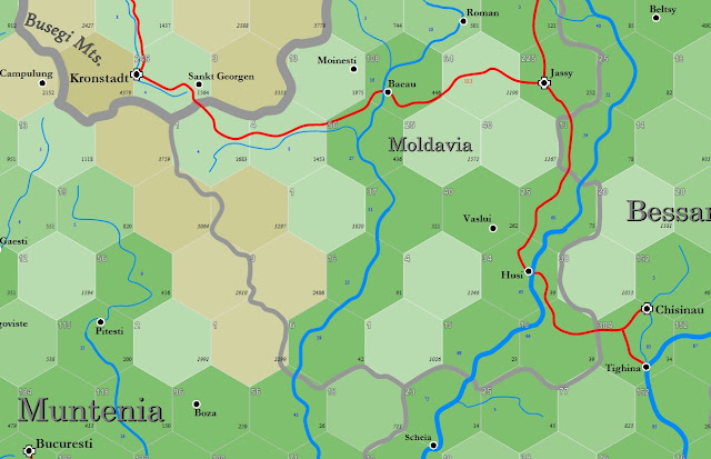
The red lines on the 20-mile map are defined by the fact that they are trade routes, not by their "road" status (though yes, they're called roads, but the exact nature of the road they pass along isn't stipulated). Husi happens to be on the shortest route from Jassy to Chisinau, two market towns; Vaslui is not on that route. Husi is the passage way across the Prut river. I've added a map to the post to show what I mean. (cont...)
Trade route maps are not intended to be absolutely universal. For example, there's no trade route directly between Kronstadt and Chisinau. This is because, arguably, the K to C route would have to pass through Jassy's territory of Moldavia, and Jassy is entitled to make sure that all trade passing through Moldavia goes to Jassy first. There are exceptions to this, in the multiplicity of 20-mile sheet maps I've made, but in this case, Jassy has a monopoly on trade coming eastward from Kronstadt, and Kronstadt likewise has that monopoly on trade entering from Moldavia into Transylvania.
Thus, Vaslui's size and importance means nothing with regards to these trade routes. It's not on a river, it's out of the way from Jassy to Chisinau. It does occupy a gap in the hills to the north and south, so it would make sense as a military outpost, perhaps there to stop caravans attempting to bypass Jassy ... or a Transylvanian army attempting to gain access to the Prut Valley.
Coming back around to Kronstadt and Campulung. I don't know what you mean by "... the 20 mile hex there is definitely a way to get from Kronstadt to Campulung represented by the thickest red line." I see no red line between these two places. I see Kronstadt in a hex with an elevation of 1564 ft. above sea level. And a brown hex with an elevation of 4379 ft. And Campulung's hex with an elevation of 2152 ft. Building a road from Kronstadt to Campulung would require climbing 2,815 ft. up, then going 2,227 ft. down. That's more than 5,000 verticle feet up and down. Kronstadt counts as two "travel days" as the crow flies from Campulung by the trade system, which counts in hexes, not the locations of the places within those hexes. The elevation cost is "12.6 trade days," or 14.6 trade days altogether. Trade days are shown on the map as tiny red notes next to the roads.
I'll add a map for this too. Kronstadt trade wants to get to Krajova in Oltenia. Kronstadt is 5.7 trade days from Herrmannstadt, and another 8 days from Hermannstadt to Krajova. That's 13.7 in all. Which means one cart will get to Kravoja from Kronstadt 0.9 days before another reaches Campulung ... which still isn't Krajova.
Husi, as it happens, is also the head of navigation for the Prut, as shown in the third diagram added to the post above ... a breakdown of trade routes without the map in this part of the world.
I see the issue. There are two Campulungs. I am talking about the Campulung in the absolute upper right quadrant of the map.
I see now that of course the Campulung you're talking about has an infrastructure of 8, it's lucky to have that much!
So I'll rephrase the example. I'm headed from Kronstadt east towards Bacau. You're saying the 20 mile red lines are a trade route and therefore guarantee of some kind of passage, but that it will vary in quality at the 6 mile level.
If that's true, how would you adjudicate the long stretch through those mountains between the two trading points? What are those locations like? Would either power exert any influence on this road at all, or does the "wilderness" notation indicate that it's really all just a free-for-all in there, and providence alone gets folks through? What assumptions could I, the player, make about these poor-infrastructure trade routes?
Those are fuzzier questions. On the whole, I'm defining a dirt road as the minimum form along a trade route. The hex adjacent to Sankt Georgen only has an infrastructure of 1, so the road had to be so upgraded.
This doesn't work everywhere, however. There are trade routes across the Sahara, for example, which wouldn't have any infrastructure for the most part, but must still be trade routes, because those represent a no-choice option for transport.
There's a certain in-game benefit in any of the roads changing in quality. Knowing the gaps in advance and preparing for them would be a Merchant's skill ... something to block the player's pretensions of just loading up a cart and heading into gawd knows what dead ends and tragic byways.
A short 14 day journey through the mountains wouldn't be as bad as you imagine; compare it to months from Gao on the Niger River to Biskra below the Atlas mountains, a journey of months. There would be other groups moving along that road, both east and west, to and from Jassy and Kronstadt. But it does allow meetings with all the terrible D&D tropes that one might expect, doesn't it?
There's a heraldic "sage ability" I haven't written out yet: "Free Highway: learn the symbols and flags to carry, convincing brigands and others to leave the character well enough alone." It does a brigand little good if they plunder a caravan, only to have the Lord's army of 200 retainers coming to root them out and make them pay from robbing from the wrong people.


Wow. Nice work. I just browsed through some of your other posted maps. Fine work, indeed. You did all these via Publisher?
ReplyDeleteRC
Yes, Publisher. One line at a time.
ReplyDeleteThere's a road from Bacau to Kronstadt that turns to a carttrack or trail going through the mountains. Is there a methodology there for when a "Big Road" crosses over a 6 mile hex that's been determined to be wilderness?
ReplyDeleteHow would you describe or run a clearly viable trade road passing through such a place?
Again, wow. That must of been an enormous amount of hours.
ReplyDeleteI'd dispute it was a "trade road." Though, arguably, it could be one.
ReplyDeleteThe Roads & Routes system (wiki page) is designed so that each hex is responsible for making it's own roads. Campulung's 20-mile hex has an infrastructure of only "8", it has a population of only 601, so it's no better than a village. And it's high in the hills, 1,500 ft. above Ramnicu to the northwest, where the main trade route is. The size of Campulung and the altitude directly reduce Campulung's infrastructure to such a small number.
"Slatina," on the other end of the "cart path" that you reference Pandred, was randomly generated; was an unusual result, particularly plocking it down on the border, but I went with it because unusual results produce interesting dynamics. I haven't generated the hex immediately left of Slatina yet; it contains the village of Curtea, 637 ft. but at the extreme end of the Sanjak of Muntenia, or it's province. My infrastructure is also based on the province's contribution (Curtea gets no money from Oltenia) ... so that infrastructure support for Curtea has to come through Campulung. As such, Curtea's hex also has a paltry infrastructure of only 8. Looking at the surrounding layout, it will have one dirt road from Curtea to Ramnicu, a cart track into the hex on its left, a cart track to Slatina ... and nothing more than a cart path to Campulung.
All this is probably confusing, but it comes down to this. The description of "cart path" on the wiki reads, "... similar to cart tracks, but are used so infrequently that the ruts are not maintained with stone and vegetation will have encroached upon the route. This takes time to physically hold it back or cut it away. The existing centre mound will scrape the axles, causing breaks (1 in 16). In places (1 in 12) the cart will need to be levered over humps. No bridges, ferries or fords."
In other words, impassable for wagons, probably because of stone outcroppings and places where the path is no wider than two cart wheels; and places where someone has to go ahead and make sure there's no other cart coming the other way, as there are many places where neither cart could "back up." This is a highly impractical route for trade ... but it exists for foot traffic and the occasional desperate carter to use.
I know you don't need most of this explained, Pandred, but I want to be complete. Just saying there are other reasons why Campulung makes a bad trade route.
To make it a viable trade road would require breaking rock; which would require dynamite. I can't think of a practical, controllable alternative magic to dynamite, one that would leave a viable roadbed. Rock to mud would be effective, but it doesn't cover much volume, by roadbuilding standards.
I think I understand, but to tease it out a little more:
ReplyDeleteSo I have seen this map, and I want to go to Campulung from Kronstadt or wherever. You've given me the precise metrics for Kronstadt in the six mile hex AND told me that Campulung has an infrastructure of 8, so low as to be nearly meaningless.
When I look at the 20 mile hex there is definitely a way to get from Kronstadt to Campulung represented by the thickest red line, but you would reply that there is no guarantee of the quality of that passage, yes?
I stress here that I'm trying to get out the value of the 20 mile hex roads, rather than their 6 mile counterparts. You had a methodology for placing the 20 mile road indicators, and I point out Bacau to Kronstadt specifically as a place where a road important enough to exist in the 20 mile spectrum experiences a huge downgrade in "expected" quality before picking back up again in civilized lands.
Vashui, for instance, is not important enough for a 20 mile road, but there is a chance that in the 6 mile spectrum that it gets some kind of trail to link it up with Husi.
Ah, well.
ReplyDeleteThe red lines on the 20-mile map are defined by the fact that they are trade routes, not by their "road" status (though yes, they're called roads, but the exact nature of the road they pass along isn't stipulated). Husi happens to be on the shortest route from Jassy to Chisinau, two market towns; Vaslui is not on that route. Husi is the passage way across the Prut river. I've added a map to the post to show what I mean. (cont...)
(...cont)
ReplyDeleteTrade route maps are not intended to be absolutely universal. For example, there's no trade route directly between Kronstadt and Chisinau. This is because, arguably, the K to C route would have to pass through Jassy's territory of Moldavia, and Jassy is entitled to make sure that all trade passing through Moldavia goes to Jassy first. There are exceptions to this, in the multiplicity of 20-mile sheet maps I've made, but in this case, Jassy has a monopoly on trade coming eastward from Kronstadt, and Kronstadt likewise has that monopoly on trade entering from Moldavia into Transylvania.
Thus, Vaslui's size and importance means nothing with regards to these trade routes. It's not on a river, it's out of the way from Jassy to Chisinau. It does occupy a gap in the hills to the north and south, so it would make sense as a military outpost, perhaps there to stop caravans attempting to bypass Jassy ... or a Transylvanian army attempting to gain access to the Prut Valley.
Coming back around to Kronstadt and Campulung. I don't know what you mean by "... the 20 mile hex there is definitely a way to get from Kronstadt to Campulung represented by the thickest red line." I see no red line between these two places. I see Kronstadt in a hex with an elevation of 1564 ft. above sea level. And a brown hex with an elevation of 4379 ft. And Campulung's hex with an elevation of 2152 ft. Building a road from Kronstadt to Campulung would require climbing 2,815 ft. up, then going 2,227 ft. down. That's more than 5,000 verticle feet up and down. Kronstadt counts as two "travel days" as the crow flies from Campulung by the trade system, which counts in hexes, not the locations of the places within those hexes. The elevation cost is "12.6 trade days," or 14.6 trade days altogether. Trade days are shown on the map as tiny red notes next to the roads.
I'll add a map for this too. Kronstadt trade wants to get to Krajova in Oltenia. Kronstadt is 5.7 trade days from Herrmannstadt, and another 8 days from Hermannstadt to Krajova. That's 13.7 in all. Which means one cart will get to Kravoja from Kronstadt 0.9 days before another reaches Campulung ... which still isn't Krajova.
Husi, as it happens, is also the head of navigation for the Prut, as shown in the third diagram added to the post above ... a breakdown of trade routes without the map in this part of the world.
ReplyDeleteI see the issue. There are two Campulungs. I am talking about the Campulung in the absolute upper right quadrant of the map.
ReplyDeleteI see now that of course the Campulung you're talking about has an infrastructure of 8, it's lucky to have that much!
So I'll rephrase the example. I'm headed from Kronstadt east towards Bacau. You're saying the 20 mile red lines are a trade route and therefore guarantee of some kind of passage, but that it will vary in quality at the 6 mile level.
If that's true, how would you adjudicate the long stretch through those mountains between the two trading points? What are those locations like? Would either power exert any influence on this road at all, or does the "wilderness" notation indicate that it's really all just a free-for-all in there, and providence alone gets folks through? What assumptions could I, the player, make about these poor-infrastructure trade routes?
Those are fuzzier questions. On the whole, I'm defining a dirt road as the minimum form along a trade route. The hex adjacent to Sankt Georgen only has an infrastructure of 1, so the road had to be so upgraded.
ReplyDeleteThis doesn't work everywhere, however. There are trade routes across the Sahara, for example, which wouldn't have any infrastructure for the most part, but must still be trade routes, because those represent a no-choice option for transport.
There's a certain in-game benefit in any of the roads changing in quality. Knowing the gaps in advance and preparing for them would be a Merchant's skill ... something to block the player's pretensions of just loading up a cart and heading into gawd knows what dead ends and tragic byways.
A short 14 day journey through the mountains wouldn't be as bad as you imagine; compare it to months from Gao on the Niger River to Biskra below the Atlas mountains, a journey of months. There would be other groups moving along that road, both east and west, to and from Jassy and Kronstadt. But it does allow meetings with all the terrible D&D tropes that one might expect, doesn't it?
There's a heraldic "sage ability" I haven't written out yet: "Free Highway: learn the symbols and flags to carry, convincing brigands and others to leave the character well enough alone." It does a brigand little good if they plunder a caravan, only to have the Lord's army of 200 retainers coming to root them out and make them pay from robbing from the wrong people.
So, not quite a free-for-all.