Given that I don't have to generate rivers, highlands, towns, etc., because I am using a map of my own making, I've got the first trouble worked out (still doing leg work). That is, starting with a group of 7 junior hexes, calculate which are 'wild' and which are 'settled.' In a previous post I referred to these as uninhabitable and habitable, but I think this parlance works better, as it allows for the wild areas to still support a population; its presumed that what isn't supported in the wild areas is a) permanent infrastructure or b) industry.
Step two, to work out the course of the river within the 7-hex group, given that the river's entrance into the hex and the river's exit from the hex are known. Thus, the rivers can follow a wide variety of paths, looping or meandering. I've decided not to regulate the flow of the river by the settled or wild hexes, as this increases variety. I haven't started yet to work out the algorithm for a hex where the river starts, but again, since the exit side is known, that shouldn't be too much trouble.
So, if you have drawn a map, and you have drawn the river on that map, you can use the generator to shape the river as you zoom in. You could then use the generator to shape the river further as you zoom in again and again, as each junior hex spawns in turn its own junior hexes.
I have the added benefit of knowing the 'size' of my rivers, as shown no the bit of map below:
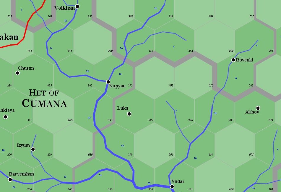
With 1 point (expressed in blue numbers on the map) equalling approximately 8-12 feet in width and 1 foot in depth (its really a guideline rather than a rule, as not all rivers obey the same groundwater laws), there is a point when zooming in further causes the river to be the same width as the hex that holds it ... but then, that should be obvious.
Fine. Once I have rivers and hexes designated, I can start to identify where the roads might be. As you can see from the corner of the above, roads (in red) are also predetermined; however, the red road above could be termed a 'paved' road - cobblestones and the like - there's also the matter of cart-tracks (packed earth/clay mixed with stone and gravel), byways (wide foot paths) and trails (narrow foot paths). The latter two can probably be considered ubiquitous, the first in all settled areas and the second in most hard-ground wild areas ... though of course the complete absence of a trail could indicate very wild country indeed.
Having done this, I can then proceed to designate the individual junior hexes in terms of their actual contents - where are the villages, hamlets and thorps, and what wild areas still offer easy-access water (changing the likely encounters) and so on. There's really no end to how gritty I want to get ... on some level it would be possible to get right down to identifying the name and level of the local chapel, his (or her) family, religion, etcetera, etcetera.
The idea is certainly to get gritty - and to use the format as an inspiration to determine how one should get gritty and where. It would be nice, ultimately, to be able to generate three or four pages of raw data upon any hex desired ... with the principle material on the first page, of course.
That might feel like a straightjacket for some DMs. Personally, having the name of the 4th level cleric in the neighborhood at my fingertips strikes me as abundantly gratifying; heck, I'm just going to have to invent a name anyway. This way, there's a record, so if the party comes back after 17 months of real time, I actually have it listed.
All this from an idea I had Saturday. My, how time flies. I would be failing in my responsibilities if I did not point out at this point that the nucleus of this work will be available to my subscribers in a day or two, along with upgrades as I go along. There's no reason you shouldn't get in on the ground floor, and have the opportunity to influence the work as well. I perceive that this is probably the most important new leap I've made in a couple of years, and I expect to be working on it steadily throughout 2012.
Mm. I haven't had much time to digest the idea, but I most certainly do like it.
ReplyDeleteWith those five obstacle "types", multiplied by the civ/nonciv categories...hell, even a simple set of d20 charts gets very large-seeming.
For those unaware of how Alexis tends to operate, it's a safe bet that subdivided d20 charts is laughably small shakes compared to the actual results we'll see o'er the coming months.
Keep it comin'!
"Personally, having the name of the 4th level cleric in the neighborhood at my fingertips strikes me as abundantly gratifying;"
ReplyDeleteFor a GURPS campaign, I used a program to generate every single noble and wizard (several thousand people in total).
It was fantastic.
very nice, i have one small question tho. what are the purple lines that follow the contours of some of the hexes ? some are narrow and some are thick. i didn't see you mention anything about them in this post. did you mention it in one of your other ones ?
ReplyDeleteAh, those are borders. The wide ones are national borders; the narrow ones are state borders.
ReplyDeleteOn the small bit of map, the upper part and the little bit near Volkhan is the Grand Duchy of Moskovy. The Het of Cumana is a half orc state, and is the two territories (Luka and Vodar are in Donbass). The little bit separated in the bottom right hand corner is the land of the Don Cossacks.
Incidentally, the main river is the Donets.