I've picked examples which I think demonstrates how the earth is somewhat more complex and interesting than most maps made in the imaginations of RPG players. As I've said before, making these maps has been an exploration, an understanding of the geography of places that I never had before, in spite of having been interested in maps all my life.
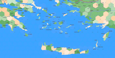
Here are the Greek Isles of the Southern Aegean:

The multiple isles of Greece make for a profound layout; it would be easy to spend years developing adventures in just this part of the world alone. Keep in mind that there are hundreds of islands not represented (they're just to small to get a good image), and that every island on this map can be located ad nauseum through wikipedia and the net for massive amounts of information dating back through 4000 years of history. What could a DM want?
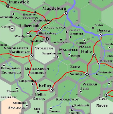
Here was the biggest headache for me so far, and it's just a small piece (I'm still smoothing out the edges of the overall map. Here is a section of Germany--Thuringia:

This is what most of Germany looks like: tiny little states, most of them only 20 to 40 miles across. On the map, the narrower lines divide minor states that are part of the Holy Roman Empire; the heavier lines divide major states. Each state can be found on Wikipedia, which will give you a load of information along with maps indicating that mine is still too simple...but with each hex being 20 miles across I had to simplify to some degree. If I made the hexes five miles across, there would be more lines with states inside states and scattered in multiple pieces over the map. Be thankful that it is this clear.
Incidentally, the complete east Germany/Poland map took me something like 150 hours to compose, with a great deal of work done and re-done.
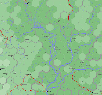
Finally, here are the Pripet Marshes:

You may notice that, if you compare this map with one out from an atlas, it appears to be oddly tilted. This is because the 30th Meridian passes straight through the marshes and, as I said in my last post, the map turns 60 degrees in concordance with the hex plan. I selected this map in part because I loved the braided stream in the center and to demonstrate that, close up, moving from hex to hex a party really wouldn't be able to tell. It helps to remember that "north" is in the upper right corner of the map, and not top center.
I apologize, incidentally, for the size of these maps; as you shrink the map you'll probably find that the fonts become difficult to read. The hex size was chosen so that I could write notes if I desired.
The black numbers in the bottom right corner of each hex are elevation figures in feet. The blue numbers following the rivers indicates the size of the river: rather than a representation of width, its more a demonstration of how much relative water the river is carrying. I couldn't put it into cubic meters per second or anything like that, as it does not represent an exact figure, but rather an account of how many hex-sides have drained specifically in that river valley. I hope to explain this at a later date.
Think of a river with 3 points as being something you might cross while only getting your calves wet, without the need of a ford, whereas a river with 30 points would be large enough to carry a fair-sized barge.
What else? I'm sure there's lots, but I'll leave it for now and add later. Hope you like the maps. I could be persuaded to post others, though for the moment I'm still waiting for that updated program.
Wow. Those are some really impressive maps!! I am starting to work on creating a campaign world myself, and am currently hung up on *how* to create a campaign world. Not so much the politics, but the very basic geography and terrain. Not necissarily as detailed as your maps, but a basic outline.
ReplyDeleteAny suggestions??
I'm not sure how flexible your map data is with regards to manipulating the size of any given hex, but the Winkel 3 projection may help as it's formula for calculating x or y coordinates is most consistent with relative distance at a given scale over any latitude.(it's not perfect, but it has the best estimation of any other projection)
ReplyDeleteGiven the nature of the map and its intended use (the key element for the selection of projection model) Winkel could be better for your purposes. At least until the party attempt to travel across the Atlantic or Pacific oceans.
http://en.wikipedia.org/wiki/Winkel_Tripel_projection
Of course, for gaming purposes, I absolutely have to recommend that you look into the Dymaxion map projection (an icosahedron projection).
http://en.wikipedia.org/wiki/Dymaxion_projection
Mudbunny,
ReplyDeleteI'd recommend picking up a book on geology, something along the lines of a first year textbook. Beyond that, I'd counsel against trying to make a map of your own beyond a few general terrain strokes.
Most of the maps I've seen created by those with no interest or knowledge in geography have concentrated on the fantastical nature of their map...which is perfectly reasonable. Maps which exist for the pure irrationality of their terrain make good backgrounds for magical campaigns.
Anonymous,
ReplyDeletePerhaps if I had considered using it years ago, I might have gone this route as a template. Alas, I am committed to the system I'm using now.
Where the hell were you in 2002?
Alexis,
ReplyDeleteWhat I was thinking of doing was taking maps of the world, and moving things around a little bit. Rotate this continent sideways, chop off a bit here, move this island chain there, that sort of thing.
Mudbunny,
ReplyDeleteI have done that in the past and I am currently doing it again. Google Maps + a screen shot with Gimp(or Photoshop) = DIY Fantasy map.
There are plenty of great places to work off of. Greece, Ireland, Scotland, Italy... just to name a few. Scale is irrelevant to a certain extent. Ireland, for example, could be a much larger island, but it would be difficult to pull it off as a continent. France has excellent place names for a fantasy game, as does Germany or Norway.
-Mike