Before I get down to serious matters, I'd like to catch up with a couple of maps I've made lately. In terms of viewership, these are not doing so well lately - but I've been told by some that they love 'em, so I'm more than happy to cater to a few fans.
The first is nothing special. I've posted
one like it before - this is merely updated for a more elaborate program, with a different color scheme, and with infrastructure numbers all over it. It really sucks when a computer dies, and takes a program with it ... but I'm very well adjusted now to the updated publisher, and I like the additional features it offers.
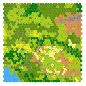
Here's a map of Eastern Europe focused on the Carpathians:
 |
Includes coniferous forest (dark green); deciduous forest (brown);
prairie (light yellow); and mixed deciduous and coniferous (olive green)
Patterned areas in mixed yellow and green, identified by
infrastructure numbers, indicate heavily settled areas |
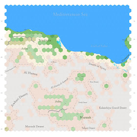
The other map is wholly new ... and mostly empty. Where I have no details for a hex, the color of that hex uses the local vegetation as a default. This is the central part of modern day Libya:
 |
Green areas and unpatterned brown areas represent
arable land. Yellow areas along the coast are thin grasslands.
Ferrous red areas have thin scrubland, but no oases; some such
areas might have deep unknown water sources. Gray areas
are pure desert.
|
My favorite part of this process is being able to intensively map parts of the world - based on plotted cities and elevation numbers, vegetation maps and with some help from Google Earth - for which I have no maps. Researching through Wikipedia reveals some gems, too. It all comes together in the sort of map above, which is described as empty in most any map you'll find online of Libya. It is, in reality ... because this represents about 300,000 square miles. Even so, it has character now, where it had none before.


No comments:
Post a Comment